


PRECINCT BRT 2, Mahoning County, Ohio
About
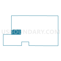
Outline

Summary
| Unique Area Identifier | 649720 |
| Name | PRECINCT BRT 2 |
| County | Mahoning County |
| State | Ohio |
| Area (square miles) | 12.64 |
| Land Area (square miles) | 11.74 |
| Water Area (square miles) | 0.90 |
| % of Land Area | 92.86 |
| % of Water Area | 7.14 |
| Latitude of the Internal Point | 41.00785610 |
| Longtitude of the Internal Point | -80.95266580 |
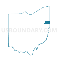
Maps

Graphs
Select a template below for downloading or customizing gragh for PRECINCT BRT 2, Mahoning County, Ohio


Neighbors
Neighoring Voting District (by Name) Neighboring Voting District on the Map
- DEERFIELD B Voting District, Portage County, OH
- PRECINCT BRT 1, Mahoning County, OH
- PRECINCT BRT 3, Mahoning County, OH
- PRECINCT ELT 1, Mahoning County, OH
- PRECINCT ELT 3, Mahoning County, OH
- PRECINCT GOT 1, Mahoning County, OH
- PRECINCT GOT 3, Mahoning County, OH
- PRECINCT SMT 1, Mahoning County, OH
Top 10 Neighboring County Subdivision (by Population) Neighboring County Subdivision on the Map
- Smith township, Mahoning County, OH (4,510)
- Goshen township, Mahoning County, OH (3,243)
- Deerfield township, Portage County, OH (2,822)
- Ellsworth township, Mahoning County, OH (2,217)
- Berlin township, Mahoning County, OH (2,122)
Top 10 Neighboring Unified School District (by Population) Neighboring Unified School District on the Map
- West Branch Local School District, OH (13,100)
- Southeast Local School District, OH (11,574)
- Western Reserve Local School District, OH (4,129)
Top 10 Neighboring State Legislative District Lower Chamber (by Population) Neighboring State Legislative District Lower Chamber on the Map
- State House District 68, OH (124,596)
- State House District 61, OH (116,012)
- State House District 59, OH (112,255)
Top 10 Neighboring State Legislative District Upper Chamber (by Population) Neighboring State Legislative District Upper Chamber on the Map
Top 10 Neighboring 111th Congressional District (by Population) Neighboring 111th Congressional District on the Map
Top 10 Neighboring Census Tract (by Population) Neighboring Census Tract on the Map
- Census Tract 8130, Mahoning County, OH (4,531)
- Census Tract 8129, Mahoning County, OH (4,339)
- Census Tract 8133, Mahoning County, OH (3,241)
- Census Tract 6019.02, Portage County, OH (2,822)
Top 10 Neighboring 5-Digit ZIP Code Tabulation Area (by Population) Neighboring 5-Digit ZIP Code Tabulation Area on the Map
- 44460, OH (26,732)
- 44609, OH (3,987)
- 44451, OH (3,032)
- 44401, OH (2,892)
- 44411, OH (2,181)
- 44449, OH (1,323)